Carroll County
Recorder’s Office: Land Information
About The Carroll County Recorder’s Office

Office Phone: 330-627-4545
Office Fax: 330-627-4295
Office Hours: Mon-Fri 8am-4pm
HISTORY OF PUBLIC LANDS
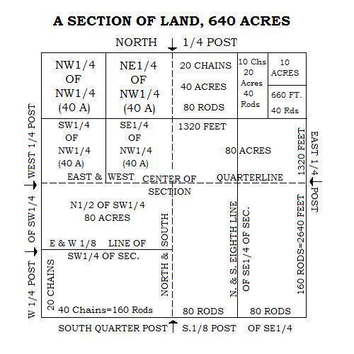
Thomas Jefferson was involved in the creation of the public land measurement system. Land description that we use today is possible because of this rectangular measurement system.
The measurement system went through a 21-year trial and error period mainly in Ohio. The system was found workable and adopted as the U.S. Land Measurement System in 1805.
Recorder’s Office Menu
MEASUREMENTS
| LONG MEASUREMENTS | SQUARE MEASUREMENTS | |||||
| 1 Mile | = | 80 Chains | 1 Sq. Mile | = | Regular Section | |
| 320 Rods | 640 Acres | |||||
| 5280 Feet | ||||||
| 1 Acres | = | 10 Sq. Chains | ||||
| 1 Chain | = | 4 Rods | 160 Sq. Rods | |||
| 66 Feet | 43,560 Sq. Feet | |||||
| 100 Links | ||||||
| An Acre is about 208 1/4 feet square | ||||||
| 1 Rod | = | 5 1/2 Yards | An acre is about 8 rods wide | |||
| 16 1/2 Feet | 20 rods long, or any area the product | |||||
| 25 Links | of whose length by its width (in rods) | |||||
| is 160 or in chains is 10. | ||||||
| 1 Link | = | 0.66 Feet | ||||
| 7 7/8 Inches | 1 Sq. Rod | = | 30 1/4 Sq. Yds. | |||
| 272 1/4 Sq. Ft. | ||||||
| 1 Pole | = | 16 1/2 Feet | ||||
| 1 Sq. Ft. | = | 144 Sq. Inches | ||||
| 1 Furlong | = | 220 Yards | ||||

OHIO’S HISTORIC FAMILY FARMS: PROGRAM HIGHLIGHTS
Ohio’s Agricultural Heritage REYNOLDSBURG, Ohio (May 10, 2016) – The Ohio Department of Agriculture recognizes the social, economic, and historic contributions of Ohio’s family farms through its Ohio’s Historic Family Farms Program, which recognizes farms that have remained in the same family for at least 100 years. Over 1,800 farms are registered as Century, Sesquicentennial or Bicentennial Farms, with at least two farms represented in each of the state’s 88 counties.
History
In 1993, the department began collaborating with Ohio’s Country Journal and the Ohio Historical Society to administer the Outstanding Ohio Century Farm Program. Annually, eight regional Outstanding Century Farms were announced at the Ohio State Fair, and one overall winner was unveiled at the Farm Science Review.In 2003, the department became the sole sponsor of the program, and the Outstanding Ohio Century Farm Program evolved into the Ohio Century Farm Program. To recognize the special history of each of these farms, the department presented certificates signed by the governor and the director of the Ohio Department of Agriculture to all registered farm families.
In 2013, the department adopted the Ohio Bicentennial Farm title to distinguish those farms which had reached 200 years of same-family ownership. That year, the department began recognizing the Bicentennial Farm families at their local fairs.
The Ohio Sesquicentennial Farm designation was added to the historic farms program in 2016.
The department commissioned an official yard sign available to Century Farm owners in 2005, and a Bicentennial Farm sign was first offered in 2014. These signs are now displayed across the state.
Additional Information
Visit the Web site (Ohio’s Historic Family Farms Program) for more information, including a list of current Bicentennial and Century Farms and a downloadable registration form. Assistance is also available from the department’s Office of Communication – agrcentury@agri.ohio.gov or 614-752-4505.
Contact Us
119 South Lisbon Street, Suite 205
Carrollton, Ohio 44615
Phone: 330-627-4545
Fax: 330-627-4295
Email the Recorder at:

